Drone Videography and Photography
To sell faster and smarter, put your company in the spotlight with stunning Drone Videography and Photography.
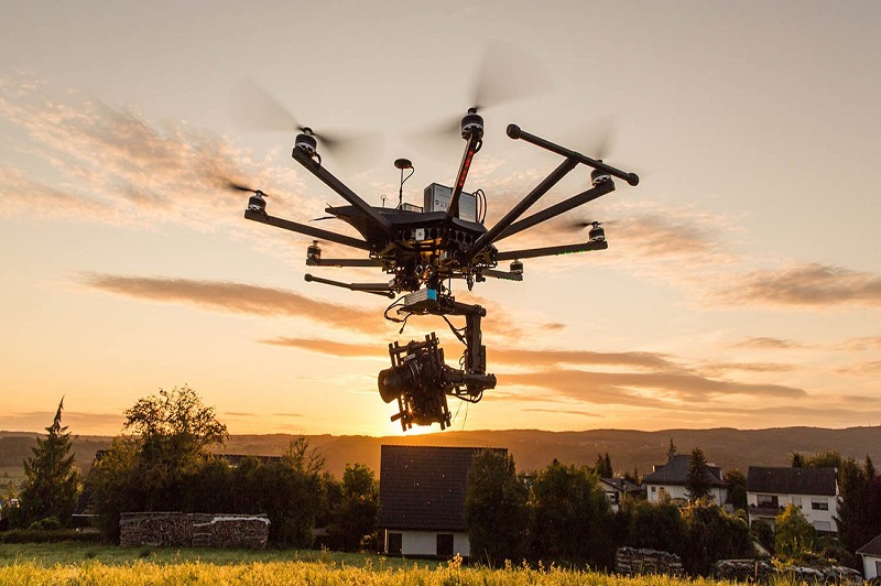
Creative Aerial Videography & Photography
We attempt to capture the most captivating vistas that are normally difficult to see as pioneers in the drone industry. Our talented drone cinematographers have continued to dazzle our clients with their spectacular drone videos and photographs all over India. Drone photography and videography is a popular tool for event coverage, tourism promotion, real estate advertising, and other uses, and we can handle it all!. Our top-tier professional filmmaking drones capture the spirit of aerial photography with their adaptable high-resolution sensors. Even so, without a well-known drone pilot, a high-end drone is useless. By embracing the knowledge and creativity required, our professional drone pilots surely provide beautiful Drone photographs. Thanks to a committed team of video editors, we translate aerial videography into the excellent experience that our clients deserve.
We conduct high-quality aerial photography shoots to deliver panoramas, images, and video tours of nearby facilities. Comprehensive and imaginative aerial imagery enables businesses to sell their property faster and more appealingly to their clients. Drones like the DJI Mavic Pro, DJI Phantom, and DJI Inspire 2 allow us to work more freely, quickly, and cost-effectively. While maintaining crowd safety, our Drone cameraman captures spectacular footage of events with 4k Resolution and 20 Megapixel Drone Images. Quadcopters are used to capture airborne photos of power plants, high voltage towers, buildings, nature, and events, among other things. With aerial photos, you may get a whole new perspective on your project!
Our Features
10x Faster Data Acquisition
We capture aerial data 10x faster than our competition thanks to our team of expert drone pilots and survey-grade drones.
5x Faster Delivery
We have a team of GIS professionals working around the clock to handle and analyse the data from the drone survey ... See More
99% Accurate Measurement
We provide findings that are up to 99 percent accurate. Machine Learning is used to process data in order to improve ... See More
Advance Equipment
Our research Drones are high-tech, with high-resolution sensors that provide higher data quality. For surveying, we ... See More
Team of Experts
Our staff of highly skilled GIS engineers, drone pilots, and software engineers are available 24 hours a day, ... See More
One to One Support
We give all necessary assistance to our clients from the beginning to the end of the project, assisting them in making better decisions using Survey data.
Let's Connect!
We're eager to hear from you. Whether it's a query or feedback, our friendly support team is here to assist. Don't hesitate to get in touch.